Gina writes:
Last week, I spent 3 days working in a rural area about 3 hours away from Koraput town. Our "home base" for the trip was one of SPREAD's field centres, 2 thatched roof buildings in a non-electrified village of 30 households.

I was accompanying my boss' wife on some work that she was doing and 3 of the program managers that I'm friends with were conducting meetings or doing field work in the area, so it was a lively group of people that I'm comfortable with and that speak good English.
Here's my friend Prasant. He was just trying to shield his skin from the sun, but I couldn't help laughing at his Unabomber-esque look!

The main purpose for our visit was to document the land titling process that SPREAD follows in helping villages to apply for and secure the appropriate land titles for their land. (Context: A vast majority of villagers in Koraput farm small patches of land, but don't actually own it. In some cases, they pay "rent" for the land and in some cases, they're just vulnerable to exploitation.) It was decided to visit the same village multiple times over the course of a few days, to document the process in-depth for one village, to be used for distribution to other NGOs who want to start similar land projects. (To clarify, this land project is not the same as the GPS/GIS work that I've been working on, which concentrates on villages that do not yet have cadastral maps to visualize their plots, but I was able to test the GPS device and some other things in actual field conditions, which was helpful.)
Visit #1
Our visit to Khajuriput on Tuesday morning was a meeting of a few hours where the SPREAD staff just asked questions about the process, which steps were taken, which steps were valuable, etc. I didn't follow the conversation at all, since it was in Oriya, but it was interesting to observe the behavior of the villagers. They were obviously quite proud of the work that had been accomplished and were very careful with the maps and documents. I could tell they were extremely important pieces of paper.
Here, some of the villagers are explaining the features of the cadastral map.

Break Time
The temperature was more than 100 degrees, which made us all exhausted by mid-day. We returned to the field centre about 10 minutes away from Khajuriput. The buildings were way too hot to spend much time in, so after lunch there were at least 3 people, including me, sacked out on the ground in the shade of a huge mango tree!

An air-conditioned room isn't missed so much when you get to nap in the shade with a breeze washing over you, hearing the chickens cluck and the cows moo to lull you to sleep.
Visit #2
At about 4:30, we returned to Khajuriput. This time, the villagers demonstrated their knowledge of chain surveying, the method of measurement that they learned when the professional surveyors came to make the cadastral map more than 20 years ago! I needed to take pictures of the process and wanted to test the GPS device out in the farm plots, so I headed out with 10 or so village men to the village boundary.
I always chuckle to myself in these situations, the tall white girl traipsing about the fields with a bunch of tribal men. I also enjoy smashing their stereotypes of foreigners. For instance, they were waiting at the vehicle for the driver to take us to the boundary point. I said (in Oriya, by the way), "How many kilometers?...One?...Oh, it's fine, let's go, no problem." And off we went to walk for a whole 10 minutes!
This man is a village leader of some sort. He was showing us how they measure distance/area with the chain (each link is 8 inches, 100 links is 66 feet, one acre is 10 chains by 1 chain).

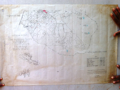
I was excited to find certain places on the cadastral map and then mark them with the GPS device. Here is the cadastral map of the village, by the way.
I asked the men to lead me around the boundary of one entire plot, so that I could track it with the GPS device, to test for accuracy and usability. Here we are comparing the cadastral map to the actual land cover.

In this instance, I was so happy to have legitimate work that I was doing along with the villagers, as opposed to just observing and documenting, like I usually do.
Visit #3
The next afternoon, we visited Khajuriput again. They were creating an updated version of their village's social map. The original version was created 2 years ago, when SPREAD first starting working on land issues with them.

It shows each household and then tracks certain characteristics. Social maps often track health status or education, but in this case, tracked land issues. The different symbols mark the type of land that the household farms, whether the title is in possession, and other measures.
Watching the creation of the updated version was fascinating. The entire village came together to draw the houses and roads on the ground with rice powder and reddish dirt.


Then they chose different natural items like baby jackfruit, seeds, and leaves to mark the updated status.

After the map was completed, they could better visualize the progress that has been made in the last 2 years. SPREAD makes sure to emphasize that most of the progress is because of the village's initiative, not SPREAD's assistance. Really a cool process to watch!
Gupteswar
There was some information that we were waiting for from the SPREAD staff that work in the area, so we had to stay in the field center for an extra night. That meant that we could go to Gupteswar only 12 km away! Gupteswar is a Hindu temple that's in a cave, one of the popular tourist spots of Koraput district. Corey and I had wanted to go, but never had the chance. To be honest, the temple itself wasn't that impressive, just a series of small shrines in a cave that wound downward for about 300 feet. What was more impressive to me was the river area just down the hill from the temple. Beautiful! And we were there at the perfect time for an absolutely stunning picture.

I returned to Koraput exhausted but fulfilled. When do we go again?!
A chronicle of our two-year work placement in Koraput, Orissa, India. Voluntary Services Overseas (VSO) is sending and training us. NGOs in Koraput are employing us. Corey is working as a management information systems (MIS) advisor. Gina is working as a communications advisor.
Buy Our eBook

400 pages | 150 posts | $5
Search This Blog
Blog Archive


Email Updates
To receive an email each time the blog is updated, contact ginagrone at yahoo dot com or corey at coreygrone dot com.